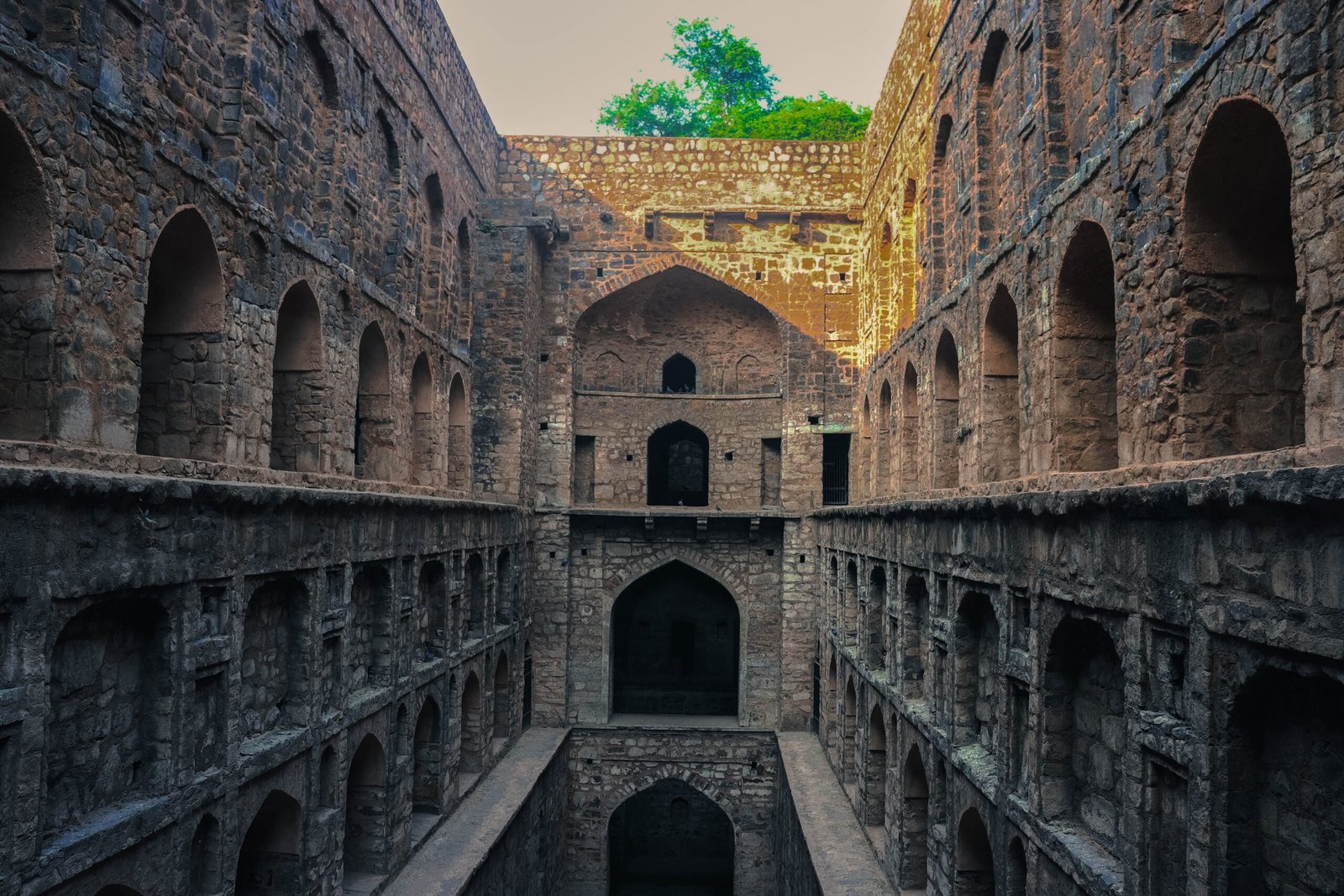
Agrasen ki Baoli architecture begins with a descent into the earth. In central Delhi, a staircase drops below the busy streets around Connaught Place into a narrow space of stone steps, high masonry walls and shadowed arches. The central design problem was practical: how could people reach a water source whose level changed through the year? The answer was not simply to dig a well, but to build a route down to it.
Also known as Ugrasen ki Baoli, Agrasen ki Baoli architecture forms part of India’s varied tradition of stepped water structures. Its significance lies in the relationship between movement, water and section. To understand it, we need to look below the street—and distinguish the building’s uncertain origins from the physical evidence that survives.

A Name Older Than the Surviving Building?
Tradition associates the baoli with Maharaja Agrasen, the legendary ruler whom the Agrawal community regards as an ancestral figure. That association is central to the monument’s identity, but it does not establish the date of its masonry. Popular accounts often collapse the legendary foundation and the surviving building into a single story, giving an impression of certainty that the evidence does not support.

The National Monuments Authority’s history assessment dates the surviving structure to the fifteenth century and identifies the Lodi period as the most likely context, while acknowledging that the exact patronage and building sequence are uncertain. The older tradition connecting the baoli with Maharaja Agrasen should therefore be presented as a foundation story, not a verified date for the masonry. The baoli was formally protected as a monument in 1913; that legal record confirms its heritage status, not its legendary origin.

This distinction matters architecturally. A water source could remain useful through successive periods of settlement, while its access stair, retaining walls and surrounding buildings were repaired or replaced. The age of a site’s use, the age of its name and the age of its visible fabric need not be identical.

Agrasen ki Baoli Architecture: Plan, Section and Water Access
Delhi’s strongly seasonal rainfall made water storage and access persistent concerns. Wells, tanks and baolis formed part of a wider landscape of water infrastructure, serving different settlements and responding to local terrain and groundwater conditions. A stepwell did something a conventional well could not: it made changing water levels accessible through an extended architectural descent.

Agrasen ki Baoli architecture is organized along a long, approximately north–south axis. Visitors enter at the southern end and descend towards the well at the north. Delhi Tourism describes the baoli as approximately 60 metres long and 15 metres wide. Those dimensions give a sense of its unusual proportions: this is not a broad reservoir approached from several sides, but a strongly directional space enclosed by substantial walls.

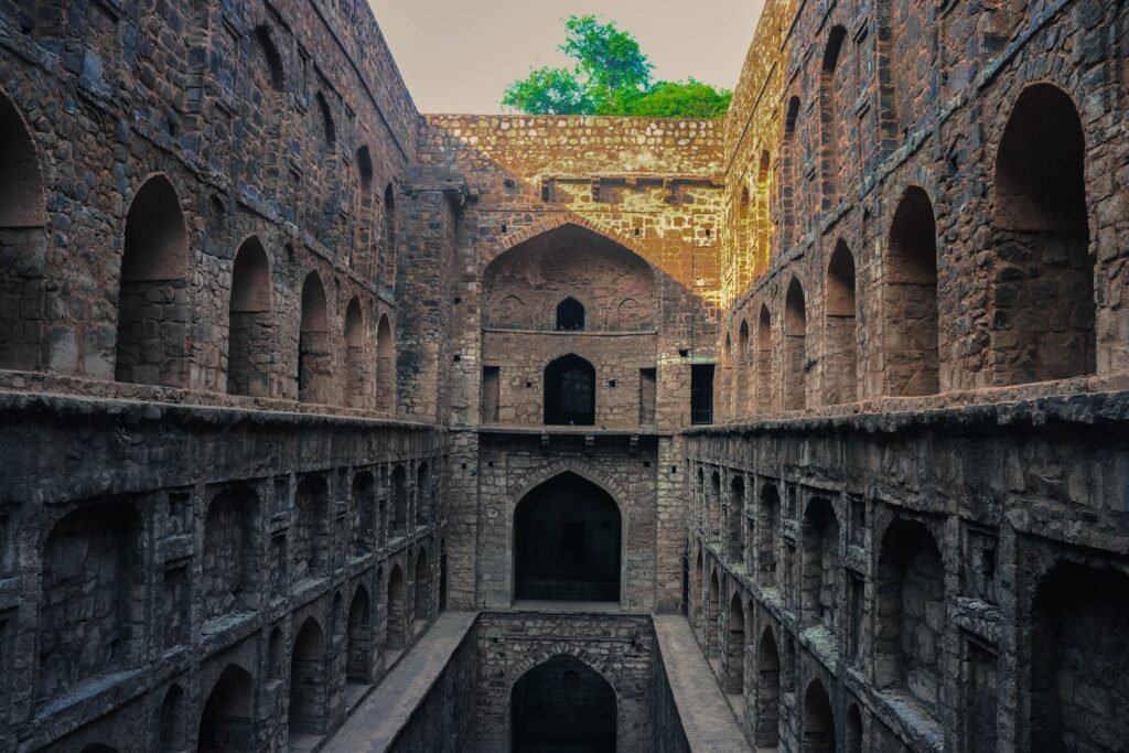
The plan is relatively straightforward; the section carries the complexity. A long flight of steps, interrupted by landings, passes through progressively deeper levels. Three tiers of arched openings articulate the lateral walls. As the waterline fell, users could descend farther; when it rose, the lower steps would become unnecessary or submerged. The stair converted seasonal fluctuation into a sequence of usable positions.
Agrasen ki Baoli: Schematic Plan, Section and Elevation
The diagrams below explain the stepwell’s spatial sequence rather than reproducing a measured architectural survey. The plan reads as a long, narrow rectangle; the section shows the descent through landings toward the well; and the elevation abstracts the repeated arched bays. Delhi Tourism describes the baoli as approximately 60 metres long and 15 metres wide. The drawings are therefore interpretive and not to scale.

Why build such an extensive approach rather than rely only on a rope and bucket? The two arrangements offered different possibilities. A shaft allowed water to be lifted, while a stepped approach brought people closer to the water and provided places to pause and circulate. At Agrasen ki Baoli, the circular well at the northern end and the long descending enclosure should be read as related components, rather than mistaking the entire visible trench for the well itself.

The staircase also makes the depth legible. From above, repeated steps and arches supply a scale against which the excavation can be understood. During descent, the street disappears from view and the enclosing walls appear to grow taller. The monument’s drama follows directly from its task: reaching water required moving through the earth.

Masonry That Holds the Ground Apart
Agrasen ki Baoli architecture is principally a work of stone masonry. Its rough-textured walls and more deliberately shaped architectural edges give it a character quite different from the densely carved stepwells often used to illustrate India’s water architecture. Here, repetition, depth and the contrast between solid wall and dark opening carry much of the visual effect.

The essential structural challenge is easy to overlook. A building above ground must carry itself down to its foundations; a deep, open excavation must also resist the surrounding ground’s tendency to move inward. The baoli’s substantial side walls establish and retain the descending space. Their thickness is therefore not merely monumental expression: it belongs to the practical demands of building below ground.

The arches allow openings within this heavy masonry. In structural terms, a masonry arch directs loads around an opening through compression into its supports. At the baoli, repeated arches and intervening piers create a rhythm along the descent while accommodating recessed spaces beside it. Their exact internal load distribution would require a measured structural investigation, but their architectural role is visible: they give depth and usable edges to what might otherwise have been an unbroken retaining wall.

Construction necessarily involved excavation and the establishment of durable retaining fabric, together with the stair and well works. A detailed historical construction sequence has not been securely established. Claims about particular building techniques or concealed foundations should therefore be treated cautiously. What survives is enough to demonstrate the coordination required between earthwork, masonry and water access.

Shade, Shelter and a Small Mosque
The baoli’s depth creates a changing relationship with Delhi’s climate. High walls shade parts of the enclosure, while the arched recesses provide more protected positions than the exposed stair. Surrounding earth and massive masonry can moderate rapid temperature changes. When water was present, evaporation could also have influenced local conditions, although precise claims about cooling would require measurements rather than impressions.

This environmental character helps explain why stepwells were more than hydraulic devices. In Steps to Water: The Ancient Stepwells of India, Morna Livingston examines them as places where water engineering, architecture and social or religious life overlapped. That wider history provides useful context, but it should not become a licence to invent a daily routine for this particular monument. Its landings and sheltered edges offered opportunities for stopping and gathering; the identities and activities of its users are less securely documented.

A small mosque stands near the southwestern edge of the complex, close to the entrance. Its surviving arcaded fabric adds another architectural layer to the site. Rather than treating it as incidental scenery, it is worth noticing how worship and water infrastructure occupy adjacent ground. Their proximity suggests the baoli belonged to a lived setting, not an isolated engineering installation. It does not, by itself, establish that the mosque and stepwell were built together.

From Working Infrastructure to Urban Monument
The architecture of Agrasen ki Baoli now sits within the dense fabric around Hailey Road, surrounded by a city very different from the landscape in which its medieval masonry was built. Its survival makes an earlier approach to water physically present inside modern Delhi. Water supply once required conspicuous spaces of access and maintenance; contemporary urban systems generally conceal those processes behind pipes, pumps and service boundaries.

The baoli is protected by the Archaeological Survey of India and is no longer an everyday public water source. Visitors commonly encounter an exposed lower enclosure rather than a functioning reservoir. Its condition should not be reduced to a single explanation: groundwater change, altered drainage and urban development can all affect historic water structures, but attributing this monument’s water history precisely would require site-specific evidence.

Conservation must therefore address more than the appearance of the stone. Retaining masonry, drainage, vegetation, deteriorating joints and visitor safety all matter to a structure whose defining space lies below ground. Its popularity as a photographic location brings welcome attention, but the most revealing view is not simply the symmetrical image from the entrance. It is the changing sequence experienced on the way down.

Agrasen ki Baoli makes a practical environmental problem readable as architecture. The stair registers a changing waterline; the walls make depth inhabitable; the recesses turn necessary infrastructure into a place to pause. Even without its former water use, it preserves a compelling idea: access to a resource can shape a public space, not merely a service system.

For a comparison with other Indian stepwells, read our features on Surya Kund in Modhera and Rani ki Vav.

Sources and Further Reading
- National Monuments Authority, history and conservation assessment for Ugrasen ki Baoli — monument history and dating discussion.
- Delhi Tourism, Agrasen ki Baoli — visitor information and stated dimensions.
- New Delhi Municipal Council, monuments — location and heritage context.
- Morna Livingston, Steps to Water: The Ancient Stepwells of India (Princeton Architectural Press, 2002) — comparative study of stepwell architecture.