
Marina Bay Sands architecture turns a three-tower hotel into a piece of city infrastructure. Designed by Safdie Architects with Aedas as executive architect, this Singapore waterfront complex connects accommodation, public space, culture, retail and convention facilities in one highly visible urban ensemble.

Marina Bay Sands Architecture: Three Towers and a SkyPark
The most recognizable gesture is the Sands SkyPark: a long public rooftop landscape bridging three hotel towers. Safdie Architects describes the complex as more than a single building: its hotel, observation spaces, gardens, museum, theatres, convention halls and public promenade form a connected urban district at Marina Bay.
The towers are not identical straight shafts. The hotel’s own architecture guide notes that they lean by as much as 26 degrees, a move that gives the group its distinct profile while shaping views toward the bay and city.

Architecture that connects the city
At ground level, the resort is organized around pedestrian links to the waterfront and surrounding transit network. The architectural idea is not only to make a dramatic silhouette; it is to pull visitors through public routes, connect indoor and outdoor destinations, and keep the bay edge active.


The SkyPark as a public roof
Set high above the bay, the SkyPark combines a publicly accessible observation deck with landscaped gardens and hotel amenities. Its great cantilever gives the building its “ship over the towers” profile, but the more lasting architectural question is how a roof can operate as a destination and skyline-level public room.


Culture beside the hotel towers
The complex also includes the ArtScience Museum, set on a waterfront promontory. Its petal-like form gives the bay a second landmark and creates a cultural destination independent of the hotel. Together, the museum, promenades and adjacent bridge turn the area into a sequence of recognizable public spaces rather than a single isolated resort.


Landscape in the sky
Planting is part of the architecture’s public image: the elevated gardens soften the megastructure and make the roof feel closer to a park than a conventional tower cap. The green layer is especially visible from nearby buildings and from the waterfront, where the SkyPark reads as a horizontal landscape hovering above the city.


Why Marina Bay Sands still matters
Marina Bay Sands is both an icon and a test case for large mixed-use development. Its dramatic form attracts attention, but its urban value comes from how the complex links the waterfront, transit, public promenades, cultural venues and elevated open space. It also raises a useful question for future megaprojects: can a building of immense scale create a legible public realm at more than one level?
Its most memorable contribution may be this vertical layering: city streets below, a cultural edge at the water, and a garden roof in the sky. The project shows how a resort can be designed as a recognizable piece of the city, while reminding us that access, pedestrian continuity and everyday public life matter as much as the skyline image. For a comparison with another landmark shaping an Asian city skyline, read our guide to the Petronas Twin Towers.


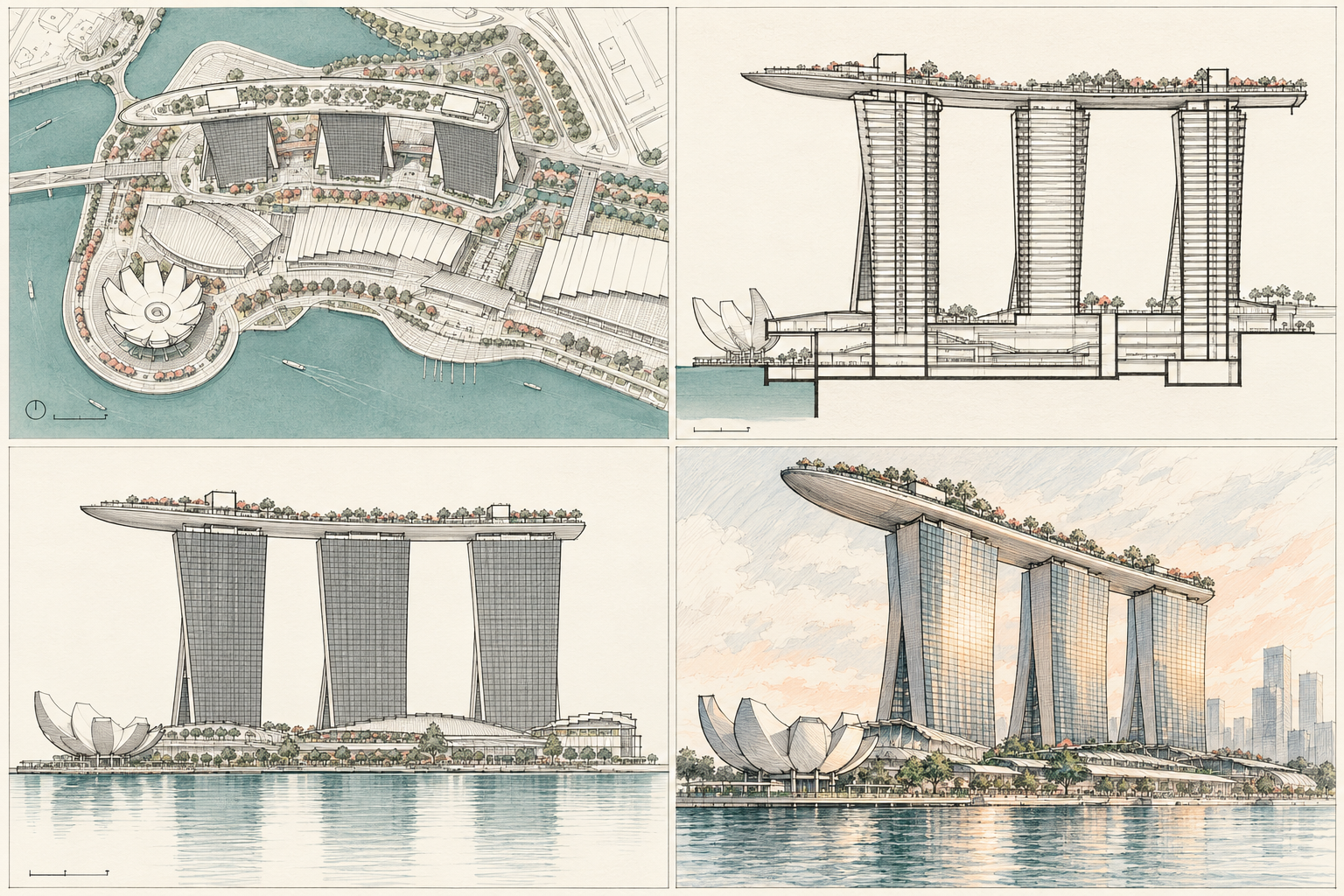
Architectural plans, sections and elevations
The drawing sheet below is an original, dimensionless analytical illustration prepared for this article. It interprets the project’s massing, waterfront relationship and SkyPark connection; it is not an official construction drawing or as-built plan.
Structure behind the SkyPark
Arup describes the SkyPark as a 340-metre-long, 38-metre-wide structure about 200 metres above ground, spanning three 55-storey hotel towers. Its engineering challenge is not simply the long span: the connected towers can move individually, so the SkyPark’s structural strategy has to accommodate their different movement.
Safdie Architects explains that five joined plates organize the SkyPark’s movement strategy. Three zones align with the hotel towers and isolate each portion laterally, allowing movement under gravity, wind and seismic loading. Arup also notes that the resort’s basement levels were built in deep marine clays, adding a demanding geotechnical condition below the visible landmark.
These facts explain the apparent unity of the roof: it reads as one continuous garden and promenade, while its support strategy responds to three towers that move individually.
The drawing is a schematic architectural analysis, not an official design or construction document; it omits dimensions and member sizes.
Technical references: Arup’s project and engineering overview and Safdie Architects’ SkyPark movement strategy.